The Coimbatore Corporation ward number list covers 100 wards divided across five administrative zones: North, South, East, West, and Central. Every resident in Coimbatore falls under one of these 100 wards, and knowing your ward number matters for everything from paying property tax to voting in local body elections to filing a complaint with your nearest zone office.
I have compiled this complete Coimbatore ward number list 2026 using official delimitation data from the Coimbatore City Municipal Corporation (CCMC). The data includes every ward boundary description, the zone each ward belongs to, and a quick reference table of ward numbers by popular area.
Whether you are searching for your ward number by location, trying to find the Coimbatore north areas list, looking for the corporation ward map, or just need to know how many wards are in Coimbatore, this guide covers everything in one place. For a broader look at Coimbatore localities, also see our complete list of areas in Coimbatore and the Coimbatore pincode list.
Note: Ward data is from the official CCMC delimitation document. Source: ccmc.gov.in delimitation of ward. Last verified: April 2026.
Key Takeaways
- Coimbatore Corporation has exactly 100 wards, each further divided into North, South, East, and West blocks.
- The 100 wards are organized under 5 administrative zones: North (20 wards), South (20 wards), East (20 wards), West (20 wards), and Central (20 wards).
- North Zone covers areas like Thudiyalur, Saravanampatti, Chinnavedampatti, Ganapathy, and Peelamedu (railway station side).
- South Zone covers Kuniyamuthur, Vellalore, Madukkarai, Kovaipudur, Eachanari, Perur, and the Pollachi Road belt.
- You can find your ward number by visiting ccmc.gov.in, checking the ward map, or contacting your nearest zone office.
How Many Wards Are There in Coimbatore Corporation?
Coimbatore City Municipal Corporation (CCMC) has 100 wards in total, divided equally across 5 administrative zones, with 20 wards per zone. Each ward is further sub-divided into North, South, East, and West blocks to define precise boundaries. The ward system was last officially delimited and published on the CCMC website. The corporation office is at Town Hall, Coimbatore 641001.
| Ward No. | Zone | Primary Areas / Landmarks |
|---|
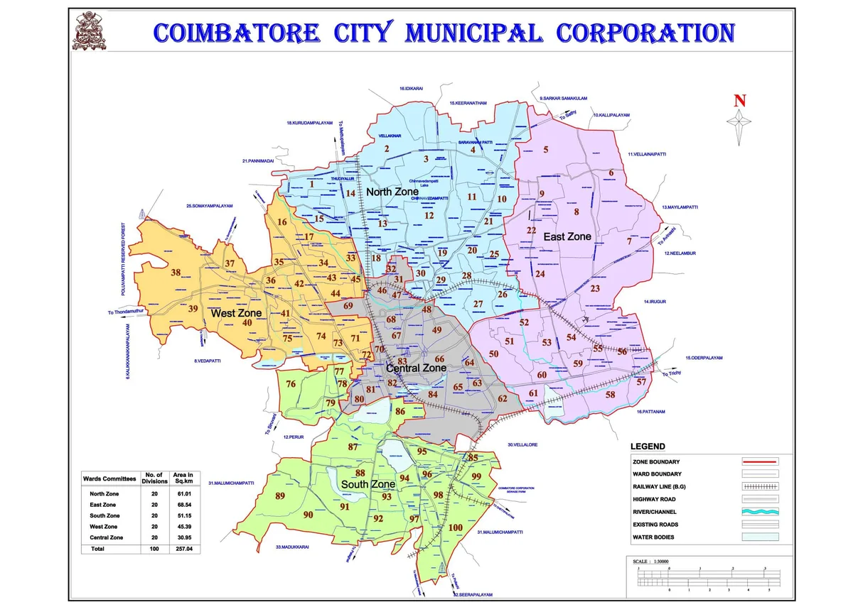
Coimbatore Corporation Ward Map
The ward map of Coimbatore shows all 100 ward boundaries across the five zones. The official PDF is available from the CCMC website.
- Official zone map PDF: https://www.ccmc.gov.in/ccmc/img/upload/Zone%20Map.pdf
- Full-size ward map image: Coimbatore Ward Map
Coimbatore Corporation 100 Ward List by Zone
All 100 wards are distributed equally across the five zones below. Use this as your quick-reference Coimbatore ward number list.
North Zone Ward List (20 Wards)
North Zone covers northern Coimbatore, including Thudiyalur, Saravanampatti, Chinnavedampatti, Ganapathy, and the Sathy Road belt.
| Ward No. | Primary Areas Covered |
|---|---|
| 1 | Thudiyalur, VKL Nagar, Ambika Nagar, Anna Colony, Vellakinar Road |
| 2 | Thudiyalur, Kurudampalayam, TNHB Phase II and III, Saravanampatti Road |
| 3 | Saravanampatti Village, Kumaraguru College of Technology, Athipalayam Main Road |
| 4 | Keeranatham, Special Economic Zone (SEZ), Saravanampatti Check Post, Sathy Road |
| 10 | Chinnavedampatti Village, KG Layout, Sathy Road, Chinnavedampatti Road |
| 11 | Chinnavedampatti, Gowmara Madalayam, Sivanandapuram |
| 12 | Chinnavedampatti Pond, Maniyakaranpalayam, Athipalayam Road |
| 13 | GN Mills area, Udayampalayam, Mettupalayam Road |
| 14 | Vellakinar, Urumandampalayam, VPV Nagar, Vellakinar-Saravanampatti Road |
| 15 | Subramaniampalayam, KNG Pudur, Kanuvai Sanganoor Pallam |
| 18 | Ganapathy Village, Nallampalayam Road, Rajiv Gandhi Road |
| 19 | Maniyakaranpalayam, Athipalayam, Udayampalayam Road (Camford School) |
| 20 | Ganapathy Maanagar, FCI Colony, BPC Colony, Sathy Road, Vilankurichi Road |
| 21 | Sivanandapuram, Vilankurichi Road, LGB Nagar |
| 25 | Gandhi Maanagar, KK Nagar, Police Quarters, Sundaram Garden |
| 26 | Ganapathy TNHB, HUDCO Colony, Avinashi Road, Vilankurichi Road |
| 27 | Peelamedu Railway Station, VK Road, PRP Garden, Avinashi Road |
| 28 | VG Rao Nagar, FCI Road, Avinashi Road, Radisson Blue area |
| 29 | North Zone (see boundary details below) |
| 30 | North Zone (see boundary details below) |
North Zone Office Address: Coimbatore City Municipal Corporation, North Zone, contact details available at ccmc.gov.in.
East Zone Ward List (20 Wards)
East Zone covers Vilankurichi, Kalapatti, SITRA, Irugur, Airport, Peelamedu Pudur, Sowripalayam, Singanallur, and the Trichy Road belt toward Vellalore.
| Ward No. | Primary Areas Covered |
|---|---|
| 5 | Vilankurichi, Kurumbapalayam Channel, Sathy Main Road |
| 6 | Kalapatti Road, Kaikolapalayam, Kurumbapalayam |
| 7 | Kalapatti, SITRA Junction, Avinashi Road |
| 8 | Kalapatti Road, Vilankurichi Road |
| 9 | Vilankurichi Road, Annai Velankanni Nagar |
| 22 | Vilankurichi Main Road, RJ School area |
| 23 | Irugur, Coimbatore International Airport (CJB), SITRA, Avinashi Road |
| 24 | CODISSIA Road, Avinashi Road, Funmall Road, Vilankurichi |
| 50 | Peelamedu Pudur, Sowripalayam, VGM Hospital, Trichy Road, Avinashi Road EB Office |
| 51 | Sowripalayam Road, PSG Hospital, Ranganayakiamman Nagar, 80 Feet Scheme Road |
| 52 | Peelamedu Pudur, Avinashi Road, Masakkalipalayam Road, RK Mill Colony |
| 53 | Uppilipalayam, ESI Hospital, Masakkalipalayam Road, Gandhi Nagar Road |
| 54 | Kamarajar Road, Valluvar Nagar, Neelikonampalayam Railway |
| 55 | Jaganathan Nagar, Airport Compound, SIHS Colony, Trichy Road |
| 56 | SIHS Colony, Sungam, Ondipudur, Irugur, Trichy Road |
| 57 | Irugur, Trichy Road, Noyyal River, Cheran Nagar |
| 58 | Vasantha Mill Road, Neelikonampalayam, Cheran Nagar, Noyyal River, Vellalore |
| 59 | ESI Hospital, Neelikonampalayam, Vasantha Mill Road, Trichy Road, Kamarajar Road |
| 60 | Uppilipalayam Road, TNHB Colony, ESI Hospital, Kamarajar Road, Trichy Road |
| 61 | Stock Exchange (Trichy Road), Anaiyankadu, Vellalore Road, Noyyal River, Sanganoor Pallam |
Central Zone Ward List (20 Wards)
Central Zone covers Gandhipuram, Bharathiyar Road, Nanjundapuram, Race Course, Gandhinagar, RS Puram, Ukkadam, and the Town Hall area.
| Ward No. | Primary Areas Covered |
|---|---|
| 31 | Central Zone (see boundary details below) |
| 32 | Central Zone (see boundary details below) |
| 46 | Sanganoor Pallam, Sathy Road, 105 Feet Bridge, Ganapathy-Gandhipuram belt |
| 47 | Ganapathy Main Road, Sanganoor Pallam, Gandhipuram 7th Street |
| 48 | Sathy Road, Aerimedu, Sanganoor Pallam, Bharathiyar Road, Gandhipuram 4th Street |
| 49 | Balasundaram Road, NG Ramasamy Road, Avinashi Road, Lakshmi Mills Junction |
| 62 | Nanjundapuram, Trichy Road, Alvernia Convent, Noyyal River, Saramedu |
| 63 | Trichy Road, Sanganoor Pallam, Auto Colony, Nanjundapuram |
| 64 | Sowripalayam Road, Puliyakulam, Pankaja Mill, Trichy Road |
| 65 | Trichy Road, Valankulam Road, Ramanathapuram (100 Feet Road), Shivaram Nagar |
| 66 | Avinashi Road, Kamarajar Road, Gandhinagar, Race Course, Club Road |
| 67 | Gandhipuram Signal, Dr. Nanjappa Road, VKK Menon Road, Avarampalayam Road, RTO Office |
| 68 | Sanganoor Pallam, Dr. Alagappa Road, Gandhipuram 4th Street |
| 69 | GCT College, Thadagam Road, Venkitapuram, Mettupalayam Road, Kikani Bridge |
| 70 | Kamarajapuram, Kikani Bridge, RS Puram DB Road, Sukrawarpet Road |
| 80 | Oppanakara Street, Podhanur Road, Periyakulam, Sundakkamuthur Bypass Road |
| 81 | Sukrawarpet Road, Oppanakara Street, Kempetty Colony, Ukkadam Bypass Road |
| 82 | Sukrawarpet Road, Railway Track, Ukkadam Bypass Road, RS Puram area |
| 83 | VOC Park Road, Balasundaram Road, RTO Office, Dr. Nanjappa Road, Lanka Corner |
| 84 | Valankulam Road, Shivaram Nagar, Sungam Bypass Road, Saramedu Road |
West Zone Ward List (20 Wards)
West Zone covers the Mettupalayam Road belt, Vadavalli, Kavundampalayam, Rathinapuri, Thadagam Road, and Maruthamalai Road areas.
| Ward No. | Primary Areas Covered |
|---|---|
| 16 | KNG Pudur, Somayampalayam, Thadagam Road |
| 17 | Sanganoor area, Mettupalayam Road belt, TVS Nagar |
| 33 | West Zone (see boundary details below) |
| 34 | West Zone (see boundary details below) |
| 35 | West Zone (see boundary details below) |
| 36 | West Zone (see boundary details below) |
| 37 | West Zone (see boundary details below) |
| 38 | West Zone (see boundary details below) |
| 39 | West Zone (see boundary details below) |
| 40 | West Zone (see boundary details below) |
| 41 | West Zone (see boundary details below) |
| 42 | West Zone (see boundary details below) |
| 43 | West Zone (see boundary details below) |
| 44 | West Zone (see boundary details below) |
| 45 | West Zone (see boundary details below) |
| 71 | Thadagam Road, Cowly Brown Road, DB Road, Ramachandra Road |
| 72 | Thiruvenkatasamy Road, DB Road, Sukrawarpet, Thadagam Road |
| 73 | Thadagam/Sundapalayam Road, Agri College, Lowley Road, Rathinapuri, Chokkampalayam |
| 74 | Forest College, Maruthamalai Main Road, Bharathi Park Road, GCT area |
| 75 | Maruthamalai Main Road, Nalvar Nagar, Thondamuthur Road, PerumalKoil Street |
South Zone Ward List (20 Wards)
South Zone covers Vellalore, Karumbukadai, Kuniyamuthur, Madukkarai, Sundakkamuthur, Perur, Palakkad Road belt, Kovaipudur, Eachanari, and Chettipalayam.
| Ward No. | Primary Areas Covered |
|---|---|
| 76 | South Zone (see boundary details below) |
| 77 | South Zone (see boundary details below) |
| 78 | Perur Main Road, Chandrasekarapuram, Rajarathinam Garden |
| 79 | Perur Main Road, Sundakkamuthur Road, LIC Colony |
| 85 | Vellalore, Kurichi Tank, Pollachi Road, MGR Nagar, Kuniyamuthur boundary |
| 86 | Karumbukadai, Ukkadam south, Athupalam, Anbunagar, Periyakulam |
| 87 | Pollachi Road, Kurichi Tank, Sundakkamuthur Road, Palakkad Road, Brindavan Circle |
| 88 | Palakkad Road, Senkulam Road, Sundakkamuthur Road |
| 89 | Ramachettipalayam, Press Enclave |
| 90 | Sundakkamuthur-Perur Road, Thottarayan Kovil, Arivoli Nagar, MGR Nagar |
| 91 | Palakkad Main Road, Senkulam, Manjipallam, Arivoli Nagar |
| 92 | Palakkad Main Road, BK Pudur, Madurai Veeran Kovil, Senthamil Nagar |
| 93 | Palakkad Road, Annama Naicker Street, Kurichi Kulam, BK Pudur, Siruvani Salai |
| 94 | Kurichi Tank, GK Square, Pollachi Road, Madukkarai Market Road |
| 95 | Pothanur Road, Noyyal River, Athupalam, Pollachi Road, Kovaipudur area |
| 96 | Pollachi Road, Gandhiji Road, TNHB Phase-1, Madukkarai Market Road, Kuniyamuthur belt |
| 97 | Madukkarai Market Road, TNHB Phase 2, Palakkad Railway, Eachanari |
| 98 | Sarada Mill Road, Muthumariamman Kovil, Pollachi Road, Sidco, Kuniyamuthur |
| 99 | Sarada Mill Road, Church Road, Chettipalayam Road, Masthan Saibu area |
| 100 | Asbestos Company area, Chettipalayam Road, Eachanari, Pollachi Road |
Ward Numbers for Popular Areas in Coimbatore
This is the section most Coimbatore residents are looking for. If you need the ward number for a specific area, check the table below. Where an area spans more than one ward, all relevant ward numbers are listed.
| Area | Ward No(s). | Zone |
|---|---|---|
| Thudiyalur | 1, 2 | North |
| Saravanampatti | 3, 4 | North |
| Keeranatham | 4 | North |
| Chinnavedampatti | 10, 11, 12 | North |
| Maniyakaranpalayam | 12, 13, 19 | North |
| Vellakinar | 14 | North |
| Subramaniampalayam | 15 | North |
| Ganapathy | 18, 20 | North |
| Gandhi Maanagar | 25 | North |
| Peelamedu (railway side) | 27, 28 | North |
| BPC Colony | 20 | North |
| Vilankurichi | 5, 8, 9, 22 | East |
| Kalapatti | 6, 7, 8 | East |
| SITRA area | 7 | East |
| Irugur | 23, 57 | East |
| Airport (CJB) area | 23, 55 | East |
| Sowripalayam | 50, 51 | East |
| Peelamedu Pudur | 50, 52 | East |
| Masakkalipalayam | 52, 53 | East |
| Singanallur | 54, 59 | East |
| Neelikonampalayam | 54, 58, 59 | East |
| Ondipudur | 56 | East |
| Vellalore (Trichy Road side) | 58, 61 | East |
| Gandhipuram | 47, 48, 67, 68 | Central |
| Bharathiyar Road area | 48, 49 | Central |
| Nanjundapuram | 62, 63 | Central |
| Ramanathapuram | 62, 63, 65 | Central |
| Puliyakulam | 64 | Central |
| Race Course | 66 | Central |
| RS Puram | 70, 72, 82 | Central |
| Ukkadam | 80, 81, 82 | Central |
| VOC Park/Town area | 83 | Central |
| Sungam | 56, 65, 84 | Central/East |
| KNG Pudur | 15, 16 | West/North |
| Thadagam Road belt | 71, 72, 73, 74 | West |
| Rathinapuri | 72, 73 | West |
| Maruthamalai Road | 74, 75 | West |
| Kuniyamuthur | 96, 97, 98, 99 | South |
| Vellalore (south) | 85, 99 | South |
| Madukkarai | 94, 96, 97 | South |
| Kovaipudur area | 91, 92, 93, 95 | South |
| Eachanari | 97, 100 | South |
| Perur | 78, 79, 90 | South |
| Karumbukadai | 86 | South |
| Athupalam | 86, 95 | South |
How to confirm your exact ward number: The table above is a general guide based on official boundary descriptions. Because many areas span more than one ward, the most accurate method is to check the CCMC website with your specific address. See the section below for step-by-step instructions.
How to Find Your Ward Number in Coimbatore
You can find your Coimbatore ward number in three ways: the CCMC website, the ward map, or by visiting your zone office in person. The CCMC website is the fastest if you have an internet connection.
The quickest method is to visit ccmc.gov.in and look up the delimitation document, or call the CCMC helpline at 0422-2399800 with your address. The ward officer will confirm your ward number within minutes. You can find all key Coimbatore government helpline numbers in our Coimbatore helpline numbers guide.
Method 1: CCMC Official Website (Online)
- Open ccmc.gov.in on your phone or computer.
- Go to the “Delimitation of Ward” section under the Corporation menu.
- Download the ward delimitation document.
- Search for your street name, landmark, or SF number.
- The ward number listed next to your area is your ward number.
If the website is slow (it often is), proceed to Method 2.
Method 2: Use the Ward Map
- Open the Coimbatore Corporation Ward Map on this site.
- Zoom into your area.
- Each coloured zone section is labelled with its ward number.
- You can also download the official zone map PDF directly from ccmc.gov.in.
Method 3: Visit Your Zone Office
If you cannot find your ward number online, walk into the nearest Corporation zone office and ask at the reception. Tell them your street address, and they will look up your ward and block number on the spot. There is no fee for this.
Coimbatore Corporation Zone Offices:
| Zone | Area | Contact |
|---|---|---|
| North Zone | Saravanampatti, Chinnavedampatti, Ganapathy | Visit CCMC North Zone office or call 0422-2399800 |
| East Zone | Vilankurichi, Kalapatti, Peelamedu, Sowripalayam | Visit CCMC East Zone office |
| Central Zone | Gandhipuram, RS Puram, Ukkadam, Town Hall | CCMC Head Office, Town Hall, Coimbatore |
| West Zone | Vadavalli, Thadagam Road, Maruthamalai | Visit CCMC West Zone office |
| South Zone | Kuniyamuthur, Madukkarai, Kovaipudur | Visit CCMC South Zone office |
How to Find Ward and Block Number in Coimbatore Online
The ward number and block number are two different things. The ward number (1 to 100) identifies which ward you are in. The block number (North, South, East, or West) identifies which sub-section of that ward you are in.
To find both your ward and block number online:
- Go to ccmc.gov.in.
- Navigate to the delimitation of ward section.
- Find your ward number using your street, landmark, or SF number from the boundary descriptions.
- Your block will be one of four: North, South, East, or West, as described in the ward boundaries.
For example, if you live on Vellakinar Road near Thudiyalur Railway Gate, you are in Ward 1, East Block (based on the official boundary description). Ward and block numbers are also useful when visiting government offices. If you need certificates from the Tahsildar Office in Coimbatore, your ward number will be required on the application form.
The full boundary descriptions for all 100 wards are listed further below in this guide.
Coimbatore North Zone Areas List
The Coimbatore North Zone has 20 wards (1, 2, 3, 4, 10, 11, 12, 13, 14, 15, 18, 19, 20, 21, 25, 26, 27, 28, 29, 30). It covers the northern belt of the city.
Key areas in Coimbatore North Zone:
Thudiyalur, Saravanampatti, Kumaraguru College area, Keeranatham, Special Economic Zone (SEZ), Chinnavedampatti, Maniyakaranpalayam, Athipalayam, Vellakinar, Urumandampalayam, Subramaniampalayam, KNG Pudur, Kanuvai, GN Mills area, Ganapathy Village, Ganapathy Maanagar, Nallampalayam, Sivanandapuram, FCI Colony, BPC Colony, Gandhi Maanagar, KK Nagar, Ganapathy TNHB, HUDCO Colony, Peelamedu Railway Station, VG Rao Nagar.
This is the area broadly referred to as Coimbatore North or Coimbatore North Constituency in local usage.
Coimbatore South Zone Areas List
The Coimbatore South Zone has 20 wards (76, 77, 78, 79, 85, 86, 87, 88, 89, 90, 91, 92, 93, 94, 95, 96, 97, 98, 99, 100). It covers the southern belt from Ukkadam outwards along the Pollachi Road and Palakkad Road corridors.
Key areas in Coimbatore South Zone:
Vellalore, Kurichi, Karumbukadai, Athupalam, Periyakulam, Anbunagar, Pollachi Road belt, Madukkarai, Brindavan Circle area, Palakkad Road belt, BK Pudur, Senthamil Nagar, Siruvani Salai, Sundakkamuthur, Perur, Arivoli Nagar, MGR Nagar, Thottarayan Kovil area, Manjipallam, GK Square, Kurichi Tank, Madukkarai Market Road, Kuniyamuthur, Sarada Mill Road, Muthumariamman Kovil, Church Road, Eachanari, Chettipalayam, Masthan Saibu area, Sidco, Kovaipudur area, Athupalam, Pothanur Road.
This is the area broadly referred to as Coimbatore South in local usage.
Coimbatore East Zone Areas List
The Coimbatore East Zone has 20 wards (5, 6, 7, 8, 9, 22, 23, 24, 50, 51, 52, 53, 54, 55, 56, 57, 58, 59, 60, 61). It covers the eastern side of the city from Vilankurichi through Kalapatti, Airport, and the Trichy Road corridor.
Key areas in Coimbatore East Zone:
Vilankurichi, Kurumbapalayam, Kalapatti, Kaikolapalayam, SITRA, Coimbatore International Airport (CJB), Irugur, Sowripalayam, Peelamedu Pudur, PSG Hospital area, Ranganayakiamman Nagar, Masakkalipalayam, Uppilipalayam, Gandhi Nagar Road, ESI Hospital area, Kamarajar Road, Singanallur area, Neelikonampalayam, Jaganathan Nagar, SIHS Colony, Ondipudur, Sungam, Cheran Nagar, Noyyal River belt, Vellalore (Trichy Road side), Vasantha Mill Road, Stock Exchange area, Anaiyankadu.
This is the area broadly referred to as Coimbatore East in local usage.
Coimbatore West Zone Areas List
The Coimbatore West Zone has 20 wards (16, 17, 33, 34, 35, 36, 37, 38, 39, 40, 41, 42, 43, 44, 45, 71, 72, 73, 74, 75). It covers the western belt including the Mettupalayam Road corridor, Thadagam Road, Vadavalli, and Maruthamalai Road areas.
Key areas in Coimbatore West Zone:
KNG Pudur, Somayampalayam, Mettupalayam Road belt, TVS Nagar area, Sanganoor area, Vadavalli, Kavundampalayam, Rathinapuri, Chokkampalayam, Thadagam Road corridor, Cowly Brown Road, DB Road, Sukrawarpet area, Thiruvenkatasamy Road, Agri College area (Tamil Nadu Agricultural University), Sundapalayam, Lowley Road, Ramakrishnapuram, Forest College campus, GCT (Government College of Technology), Bharathi Park Road, Maruthamalai Main Road, Nalvar Nagar, Thondamuthur Road, PerumalKoil Street, Kalveerampalayam.
This is the area broadly referred to as Coimbatore West in local usage.
Coimbatore Central Zone Areas List
The Coimbatore Central Zone has 20 wards (31, 32, 46, 47, 48, 49, 62, 63, 64, 65, 66, 67, 68, 69, 70, 80, 81, 82, 83, 84). It covers the heart of the city: Gandhipuram, RS Puram, Race Course, Ukkadam, and the Town Hall area.
Key areas in Coimbatore Central Zone:
Sanganoor Pallam belt, Ganapathy Main Road, Gandhipuram, Bharathiyar Road, Aerimedu, Gandhipuram 4th Street and 7th Street, Balasundaram Road, NG Ramasamy Road, Avinashi Road belt, Lakshmi Mills, Nanjundapuram, Ramanathapuram (100 Feet Road area), Auto Colony, Sowripalayam (Puliyakulam side), Pankaja Mill area, Valankulam, Shivaram Nagar, Race Course, Club Road, Gandhinagar, Kamarajar Road, Dr. Nanjappa Road, VKK Menon Road, Avarampalayam Road, RTO Office, Dr. Alagappa Road, GCT area, Thadagam Road (GCT end), Venkitapuram, NSR Street, Kikani Bridge, RS Puram DB Road, Sukrawarpet Road, Oppanakara Street, Kempetty Colony, Ukkadam Bypass Road, Podhanur Road, Periyakulam, VOC Park Road, Balasundaram Road, Lanka Corner, Valankulam, Saramedu, Sungam Bypass Road.
Complete Coimbatore Corporation 100 Ward Boundary List
The following section lists the official CCMC boundary descriptions for all 100 wards. Each ward is divided into North, South, East, and West blocks. Use this data to precisely identify your ward and block number based on the roads and landmarks nearest to your address.
Data source: Coimbatore City Municipal Corporation official delimitation document. View source
Coimbatore Ward 1
Ward 1 North: Starts from S. F. No. 204 of Thudiyalur Village, Udayakumar Thottam towards North East via Johnbosco Nagar, Saravana Nagar, crossing Eashwar Sakthi Nagar, Palanigoundenpudur Road, S. F. No. 206 Soundararajan Thottam via Mullai Nagar, Suruthi Avenue, Eashwara Nagar Boundary via towards South Chettiar Thottam, Sowdambika Nagar Pallam via Mettupalayam Road Junction, then towards South Vellakinar Road via, towards East including Ambika Nagar, Manis Nagar, Anna Colony Entrance, Thudiyalur Ward Office, Vellakinar Road Southern Side via upto Thudiyalur Railway Gate.
Ward 1 East: Starts from Vellakinar Road Thudiyalur Railway Gate towards South, VPV Nagar, Viswanathapuram Boundary upto Chinnavedampatti Canal, towards West abutting Canal upto Mettupalayam Road Junction, in Mettupalayam Road West Side towards South upto VKL Nagar Road.
Ward 1 South: Starts from Main Road approaching VKL Nagar, Northern Side SB Steels Compound onwards West SP Nagar, Gurusami Nagar, Valarmathi Nagar, VRV Avenue, Thotta Salai via upto Sanganoor Pallam.
Ward 1 West: Starts from Kanuvai Sanganoor Pallam abutting Yuvabharathi School towards Northeast Kazhaignar Nagar, SS Nagar via upto S. F. No. 204 of Thudiyalur Village, Udayakumar Thottam.
Coimbatore Ward 2
Ward 2 North: Starts from Mettupalayam Road Thudiyalur Police Station Northern Side, SS Kalyana Mandapam Road via, towards East Thudiyalur Modern Crematorium, towards North Crossing Idikarai Road, TNP Nagar Northern Boundary via, towards East New Muthu Nagar Boundary, Coimbatore-Mtp Railway Track, Crossing Northern Boundary, towards East TNHB Phase II, Phase III via Kurudampalayam Idikarai Junction, towards East Vattamalaipalayam Ganga Nursing College, Ramakrishna College Road, upto Chinnarayan Temple.
Ward 2 East: Starts from Northern Boundary Ramakrishna College Backside Road via upto Panchayat Union School (including School), towards South then towards East Coimbatore Public School Road via then towards South upto Thudiyalur Saravanampatti Road Junction.
Ward 2 South: Starts from Thudiyalur Saravanampatti Road and Coimbatore Public School Road Junction, towards West via Donbosco Puram, including Martin Nandavanam Apartment, Assisi Nagar via towards South including Brilliant School, Peria Thottam, there onwards West upto Vellakinar NG Pudur Road Junction.
Ward 2 West: (See North Zone boundary, connects back to Mettupalayam Road junction from Vellakinar side.)
Coimbatore Ward 3
Ward 3 North: Starts from Thudiyalur Saravanampatti Road and Coimbatore Public School Road Junction, towards West via Donbosco Puram including Martin Nandavanam Apartment, Assisi Nagar via towards South including Brilliant School, Peria Thottam, there onwards West upto Vellakinar NG Pudur Road Junction.
Ward 3 East: Starts from S. F. No. 454 Northeast Boundary, towards South upto S. F. No. 454, 455’s Southeast Village Boundary, there onwards West Saravanampatti Village Boundary via S. F. No. 456 Southeast Boundary, there onwards South Saravanampatti Village Boundary via upto S. F. No. 463 Southeast Boundary, there onwards West Saravanampatti Village Boundary via S. F. No. 466 Southeast Boundary, there onwards South Saravanampatti Village Boundary via upto Velappanayakanpudur, there onwards East Village Boundary via S. F. No. 632 Northeast Boundary, there onwards East Village Border via S. F. No. 637 Northeast Boundary, there onwards Village Boundary Saravanampatti onwards Thudiyalur Road, Kumaraguru College of Technology including, S. F. No. 593 Northeast Boundary onwards South Village Boundary, there onwards West S. F. No. 596 Southeast, towards South Tangedco Office, there onwards including Teachers Colony, Kurinji Nagar, there onwards S. F. No. 614 Southeast Area, there onwards South Village Boundary via Sakthi Nagar Southeast Boundary, towards South upto Ramakrishna Mill Northern Boundary, there onwards West Athipalayam Main Road Maniyakaranpalayam Road Junction.
Ward 3 South: Same boundary description as Ward 3 East (continuing along village boundary lines).
Ward 3 West: Starts from Vellakinar Village Boundary via towards North, including Sindhu Nagar, Arul Jothi Lay Out, Anjugam Nagar, there onwards Northwest Village Boundary of S. F. No. 348, there onwards North, crossing John N Mark Weekend, including Sri Dhaksha Apartment and YGS Nagar, towards South East including Vadugan Thottam, there onwards East Thudiyalur Road, upto Anna Nagar, there onwards North Village Boundary via Primary School, there onwards West Village Boundary via S. F. No. 383 Southwest Boundary, there onwards North Village Boundary via upto Ramakrishna Engineering College.
Coimbatore Ward 4
Ward 4 North: Starts from Thudiyalur Road 2 km away on Keeranatham Road leading to Special Economic Zone and Sathy Road Keeranatham Road, including VKV Kumaraguru Nagar, Corporation Elementary School, Kandasami Nagar upto Sathy Road.
Ward 4 East: Starts from Sathy Road towards South, Viswasapuram Antony’s Church via including Revenue Nagar, Siva Elango Nagar, Maha Nagar, upto KG Lay Out.
Ward 4 South: Starts from KG Lay Out towards West, including Jaya Nagar upto Jaya Nagar Western Boundary, there onwards North, Boyar Street Eastern Boundary via Sathy Road Upa Sandhu Southern Boundary via towards West upto Sathy Road, there onwards South, upto Saravanampatti Check Post, towards West, including Sri Ram Nagar, Ramanandha Nagar Northern Boundary via upto South-North Canal, there onwards Sri Nagar Southern Boundary via including Meenatchi Nagar, towards West Chinnavedampatti Village Boundary.
Ward 4 West: Same description as Ward 4 South (boundary continues from KG Layout westward).
Coimbatore Ward 5
Ward 5 North: Starts from Ragavi Garden towards East via VKV Nagar along Sathy Main Road via Valiyampalayam upto Kurumbapalayam Channel.
Ward 5 East: Starts from Kurumbapalayam Channel towards South crossing Thangamman Kovil Road upto Kalapatti Road and Senthottam Junction.
Ward 5 South: Starts from Kalapatti Road and Senthottam Junction towards West via 80 Feet Scheme Road upto Vilankurichi Road towards South upto Saravanampatti Road-Vilankurichi Road Junction, then towards West upto Naga Sai Temple Road, then towards South upto Thatchan Thottam, to West upto Lakshmi Garden.
Ward 5 West: Starts from Lakshmi Garden Saravanampatti Road towards North via Visuvasapuram Road crossing Sathy Road upto Ragavi Garden.
Coimbatore Ward 6
Ward 6 North: Starts from Kalapatti Road-Kurumbapalayam Road Junction towards East via Kurumbapalayam Pallam upto Ashok Nagar, Kaikolapalayam Junction.
Ward 6 East: Starts from Ashok Nagar, Kaikolapalayam Junction towards South via Muthamil Nagar, Karupparayanpalayam upto Thottipalayam Temple.
Ward 6 South: Starts from Thottipalayam Temple towards West via Rajiv Gandhi Nagar, Elango Nagar upto Nehru Nagar kuttai, towards West upto Kalapatti Road junction.
Ward 6 West: Starts from Nehru Nagar kuttai-Kalapatti Road Junction towards North via Eastern side of Naren Garden, Eastern side of JJ Nagar, crossing Kalapatti 4 Road Junction towards North upto Kurumbapalayam Channel.
Coimbatore Ward 7
Ward 7 North: Starts from Nehru Nagar East towards East via Southern side of Nehru Nagar kuttai towards North upto Elango Nagar Junction via Stalin Veethi via Thottipalayam Temple upto GKD Nagar.
Ward 7 East: Starts from Lakshmi Nagar towards South via Chinniampalayam Boundary upto RG Pudur.
Ward 7 South: Starts from RG Pudur towards West via Avinashi Road upto SITRA Junction.
Ward 7 West: Starts from SITRA Junction towards North via Kalapatti Road upto Nehru Nagar East Junction.
Coimbatore Ward 8
Ward 8 North: Starts from Kalapatti Road and Senthottam Junction towards East via Thangamman Kovil Road upto Kalapatti Road.
Ward 8 East: Starts from Thangamman Kovil Road upto Kalapatti Road Junction towards South, crossing Kalapatti Road-Vilankurichi Road Junction towards South via Kalapatti Road upto Ranga Triyam Bhava.
Ward 8 South: Starts from Ranga Triyam Bhava-Kalapatti Road towards West via Vilankurichi Road upto Sasi Avenue.
Ward 8 West: Starts from Sasi Avenue towards North via Vilankurichi Road, AM Nagar Road, then towards East, then towards North via Era Mohan Nagar upto Kalapatti Road and Senthottam.
Coimbatore Ward 9
Ward 9 North: Starts from Thatchan Thottam towards East via Saravanampatti Road upto NR Kalyanamandapam, then towards North upto Vilankurichi Road, then towards East via 80 Feet Scheme Road upto Senthottam Boundary.
Ward 9 East: Starts from Senthottam Boundary towards South via Ambedkar Nagar road upto Bankers Colony.
Ward 9 South: Starts from Bankers Colony towards West via Vilankurichi Road, then towards North upto Southern side of RJ School Bridge, then towards Southwest via Vinayagapuram Road upto Annai Velankanni Nagar.
Ward 9 West: Starts from Annai Velankanni Nagar towards Northeast via Vinayagapuram upto Lakshmi Garden.
Coimbatore Ward 10
Ward 10 North: Starts from Chinnavedampatti Village Boundary Road, towards East Sri Nagar Southern Boundary via upto South-North Canal, towards North including SPS Nagar and Ramanandha Nagar, Ramanandha Nagar Northern Boundary via towards East, Sri Ram Nagar South Boundary via upto Sathy Road Saravanampatti Check Post, there onwards North, Sathy Road Upa Sandhu via towards East including Boyar Street, Hospital Street upto Jaya Nagar Southern Boundary via towards East upto KG Layout Southern Boundary.
Ward 10 East: Starts from KG Lay Out, towards South crossing Kalapatti Road towards East Alagu Nagar via Government Quarters backside upto Amman Nagar Boundary towards South upto Vinayakapuram 8th Street.
Ward 10 South: Starts from Vinayakapuram 8th Street, towards West Sri Vetri Vinayakar Nagar via Sathy Road, there onwards North Chinnavedampatti Road via towards West upto Om Siva Sakthi Nagar.
Ward 10 West: Starts from Chinnavedampatti Road-Sathy Road Junction, Om Siva Sakthi Nagar onwards North Amman Nagar via crossing Canal, Bose Garden, there onwards West including Sri Sakthi Avenue, towards North including Meenatchi Nagar, Anna Nagar, towards East Scheme Road, there onwards North Scheme Road via upto Vivekam School Southern Side Boundary.
Coimbatore Ward 11
Ward 11 North: Starts from Gowmara Madalayam towards South abutting Canal, excluding Amman Nagar and Om Sivasakthi Nagar, towards East Chinnavedampatti Road via upto Sathy Road Junction.
Ward 11 East: Starts from Chinnavedampatti Road-Sathy Road Junction, towards South along Sathy Road, crossing Gowmara Madalayam Entrance Arch upto Sivanandapuram 2nd Street.
Ward 11 South: Starts from Sivanandapuram 2nd Street towards West upto Sarathi Store, upto Sakthi Nagar Eastern Part.
Ward 11 West: Starts from Sakthi Nagar East Part, towards North Anandha Nagar, Velmurugan Nagar via crossing Chinnavedampatti Road, Sri Sundarasamy Road via Janatha Nagar West, Nethaji Nagar Western Boundary via upto Gowmara Madalayam.
Coimbatore Ward 12
Ward 12 North: Starts from Chinnavedampatti Pond Northwest Boundary, towards East via Srivatsa Global Village upto Athipalayam Road.
Ward 12 East: Starts from Srivatsa Global Village Road-Athipalayam Main Road Junction, Western Side, towards South Chinnavedampatti Division Office via upto Maniyakaranpalayam Road-Athipalayam Road Junction.
Ward 12 South: Starts from Maniyakaranpalayam Road-Athipalayam Road Junction towards West via Kakkanji Street, Elango Street, Bharathi Street via upto Maniyakaranpalayam Bus Stop.
Ward 12 West: Starts from Maniyakaranpalayam Bus Stop towards North via Udayar Road, including Corporation Middle School, crossing Mariamman Temple, Lakshmi Nagar Western Boundary via towards North Sindhu Nagar Road via upto Anjugam Nagar Over Head Tank, there onwards East Anjugam Nagar Main Road upto Chinnavedampatti Pond Northwest Boundary.
Coimbatore Ward 13
Ward 13 North: Starts from Mtp Road GN Mills Junction, towards East crossing railway line, via Urumandampalayam Ponds Northern Boundary, including Thiru Veesar Nagar.
Ward 13 East: Starts from Sindhu Nagar Southeast Boundary, towards South, Lakshmi Nagar Western Boundary via crossing Udayampalayam Mariamman Kovil, towards South crossing Subbanayakenpudur upto Chinnavedampatti Village Boundary.
Ward 13 South: Starts from Chinnavedampatti Village Boundary, towards West including Anbu Nagar, Vijaya Nagar, Balaji Nagar, Manickavasagar Nagar, then towards North via Manickavasagar Nagar Main Road, towards West Amirtha School’s Northern Boundary, including Adhirshta Lakshmi Garden, then crossing Mettupalayam Road upto Sakthi Nagar Boundary.
Ward 13 West: Starts from Mettupalayam Road including Sakthi Nagar, towards East Southside Boundary of Government Women’s ITI Junction, towards North upto GN Mills Junction.
Coimbatore Ward 14
Ward 14 North: Starts from Mettupalayam Road-Chinnavedampatti Canal abutting, towards West Railway Track there onwards, towards North VPV Nagar Boundary, then towards East Vellakinar Saravanampatti Road via VCV School, there onwards South via Sriramman Kovil Public Toilet Back Side via upto Pond, there onwards East upto Periya Thottam.
Ward 14 East: Starts from Periya Thottam, towards Southwest upto NG Pudur Junction.
Ward 14 South: Starts from NG Pudur-Urumandampalayam Junction, towards East crossing Urumandampalayam Railway Track, Kongunadu College via crossing Mettupalayam Road upto GN Mills Bus Stop.
Ward 14 West: Starts from GN Mills Bus Stop, Mettupalayam Road via towards North Srivatsa Residency, including Aditya Residency upto Selva Muruganaar Villa, there onwards North Murugan Nagar via towards West Karthik Avenue via Gurusami Nagar Boundary, there onwards East VKL Nagar Main Road via upto Pirivanilai Tower, there onwards North Mettupalayam Road via upto Chinnavedampatti Canal.
Coimbatore Ward 15
Ward 15 North: Starts from Kanuvai Sanganoor Pallam ridge, towards East Thotta Salai via Srinivasa Nagar, Swathi Garden Boundary via Rajalakshmi Nagar, including Thirupathi Nagar, Dhamu Garden via upto Subramaniampalayam Priya Hostel.
Ward 15 East: Starts from Subramaniampalayam Priya Hostel, towards South Ganesh Nagar, MKG Lay Out via upto Government ITI.
Ward 15 South: Starts from Government ITI, towards West Vivek Nagar, Manal Thottam, Anandha Nagar Subramaniyampalayam, Burial Ground Boundary via Sakthi Avenue, Thirumalai Garden, JMV Garden via KNG Pudur upto Kanuvai Sanganoor Pallam Bridge.
Ward 15 West: Starts from KNG Pudur Bridge, KNG Pudur Mariamman Koil via Pichanda Gounder Thottam via Kanuvai Sanganoor Pallam Boundary upto Yuvabharathi School.
Coimbatore Ward 16
Ward 16 North: Starts from KNG Pudur running towards West through Sri Vari Garden, MGR Nagar ends upto Kasi Nana Gounder Pudur Sanganoor Pallam.
Ward 16 East: Starts from Somayampalayam Panchayat boundary running towards North through Perianna Nagar, Luna Nagar, Ganesh Nagar and Raj Garden ends upto KNG Pudur.
Ward 16 South: Starts from Sanganoor Pallam running towards South through Land Mark City, Adavan Nagar, Sabari Garden, Saravana Nagar and TVS Nagar road and ends upto Kumaraj Nagar, Church Road (Thadagam Road).
Ward 16 West: Starts from Church Road running towards upto Somayampalayam Panchayat boundary East through Thatsun Thottam ends.
Coimbatore Ward 17
Ward 17 North: Starts from Mullai Nagar running towards West through IT Nagar, Thenurchil Nagar and Cheran Nagar ends upto Mettupalayam Road.
Ward 17 East: Starts from Nataraj Nagar, Kanya Nagar, and Co-Operative Colony running towards North through Sanganoor Pallam ends upto Mullai Nagar.
Ward 17 South: Starts from Union Road running towards East through Ashok Nagar, Kannammal Nagar, Prem Avenue, TVS Nagar, Ram Nagar and Devi Garden and ends upto Nataraj Nagar.
Ward 17 West: Starts from Mettupalayam Road running towards South ends upto Union Road.
Coimbatore Ward 18
Ward 18 North: Starts from the existing Coimbatore North Assembly Constituency’s Northern Boundary and upto Vellakinar-Chinnavedampatti Village’s Southern Boundary.
Ward 18 East: Starts from the Junction of Nallampalayam Road and Ganapathy, Sanganoor Village Boundary towards South along Ganapathy Village Boundary upto Rajiv Gandhi Road.
Ward 18 South: Starts from Ganapathy Village Boundary and Rajiv Gandhi Road Junction, towards West Rajiv Gandhi Road via Nallampalayam Road, there onwards South Sanganoor Road, there onwards West SP Kannusami Main Road Northern Boundary (Saranganoor Road) via crossing Railway Track upto Mettupalayam Main Road.
Ward 18 West: Starts from Mettupalayam Road, Compost Yard Bridge, towards North along Mettupalayam Road (Eastern Part) crossing Railway Quarters upto Vellakinar Village Boundary.
Coimbatore Ward 19
Ward 19 North: Starts from Udayampalayam Road-Camford School, towards South Bharathiar Road via Maniyakaranpalayam, there onwards East Ravindranath Tagore Road via crossing Athipalayam Road Junction upto Sathy Road Junction.
Ward 19 East: Starts from Sathy Road (Ramakrishna Mill) Junction, towards South crossing Athipalayam Road Junction, via Sathy Road, upto Anna Nagar Junction (Surya Hospital).
Ward 19 South: Starts from Sathy Road-Anna Nagar Junction (Surya Hospital) towards West Maniyakaranpalayam Road via Abirami Nagar, Kandasami Nagar, Karpaga Vinayakar Nagar, there onwards abutting Canal towards West Rajiv Gandhi Road via upto Balamurugan Nagar Boundary.
Ward 19 West: Starts from Balamurugan Nagar abutting Canal towards North Maniyakaranpalayam Burial Ground, Saratha Garden, Elango Nagar, Nehru Nagar via crossing Sankaralinganar Road, via Aranmanai Thottam, upto Udayampalayam Road-Camford School.
Coimbatore Ward 20
Ward 20 North: Starts from Sathy Road-Ramakrishna Mill Junction, towards North including Nalli Mudaliyar Lay Out, crossing Sathy Road, towards East Vilankurichi Road via Ganapathy Maanagar upto Block I Eastern Boundary (upto Ellai Amman Kovil).
Ward 20 East: Starts from Vilankurichi Road-Ganapathy Maanagar Eastern Boundary (Ellai Amman Kovil) towards South, via Ganapathy Village Boundary, upto Ganapathy Maanagar 3rd Block Southern Boundary.
Ward 20 South: Starts from Ganapathy Maanagar 3rd Block Southern Boundary towards West, via Ganapathy Maanagar 4th Block, Om Sakthi Nagar Extension, crossing Police Quarters Road, abutting KK Nagar Eastern Boundary, Thendral Nagar, FCI Colony, via Balu Garden, reaching FCI Road, crossing FCI Godown Gate, towards North: Air Nagar, Yogiram Nagar, including BPC Colony, Subash Nagar via FCI Road both sides upto Sathy Road Junction, Ganesh Garden via reaching Athipalayam Road Junction, then towards East Om Parasakthi Mill Road, Parasakthi Nagar, K. Kamaraj Nagar, via VG Rao Nagar Phase II Part, then towards West KRG Nagar, KPG Nagar, Vaikkal, crossing Kannimar Nagar, upto Sakthi Road-Maniyakaranpalayam Road Junction.
Ward 20 West: Starts from Sathy Road-Maniyakaranpalayam Road Junction (includes Sathy Road), via Sathy Road towards North crossing Athipalayam Road Junction, upto Sathy Road-Ramakrishna Mill Junction.
Coimbatore Ward 21
Ward 21 North: Starts from Elango Street-Sarathi Stores, towards East Sivanandapuram 1st Street via Sathy Road, there onwards North Sri Vetri Vinayakar Nagar via towards East upto Vinayakapuram 8th Street, upto Saravanampatti Village Boundary.
Ward 21 East: Starts from Vinayakapuram 8th Street (Saravanampatti Village Boundary), towards South Sundaram Street, Eastern Boundary via upto Vilankurichi Road.
Ward 21 South: Starts from Sundaram Street-Vilankurichi Road Junction, towards West crossing Sathy Road, towards North, via LGB Nagar upto Saravanampatti Village Boundary.
Ward 21 West: Starts from Saravanampatti Village Boundary, via Thiruvalluvar Street Western Boundary, towards North via Elango Street, towards East upto Sarathi Store.
Coimbatore Ward 22
Ward 22 North: From Sivaram Nagar towards East via Vinayagapuram Road upto Bridge near Southern Side of RJ School.
Ward 22 East: From Bridge near Southern Side of RJ School upto Vilankurichi Main Road, then towards East upto Kanchimaa Nagar, then towards South upto Sasi West Avenue.
Ward 22 South: From Sasi West Avenue towards West via Southern Boundary of Sasi West Avenue, Kumutham Nagar, crossing Vilankurichi Road, then towards West upto West End of Udhaya Nagar.
Ward 22 West: From West End of Udhaya Nagar towards North via West Boundary of Udhaya Nagar upto Sivaram Nagar.
Coimbatore Ward 23
Ward 23 North: From Sasi Avenue towards East via Texpark Road upto Kalapatti Road Junction, towards South upto SITRA-Avinashi Road Junction, then towards Northeast via Northern Boundary of Avinashi Road upto RG Pudur.
Ward 23 East: From RG Pudur towards South via Eastern side of GKR Nagar and Airport, then towards South upto Irugur Town Panchayat Boundary.
Ward 23 South: From Irugur Town Panchayat Boundary towards West via upto Southwest End of Airport Boundary.
Ward 23 West: From West End of Udhaya Nagar towards North via West Boundary of Udhaya Nagar upto Sivaram Nagar.
Coimbatore Ward 24
Ward 24 North: From Gowthamapuri Nagar Channel towards East via Indhu Maa Nagar, crossing Vilankurichi Road towards East via Shanthi Farms upto NRI Garden.
Ward 24 East: From NRI Garden towards South via CODISSIA Road, crossing Avinashi Road, towards South upto Southeast Corner of Govt. Polytechnic Compound Wall.
Ward 24 South: From Southeast Corner of Govt. Polytechnic Compound Wall towards West via Jaganathan Nagar, Railway Line, crossing Kamarajar Road via Avinashi Road towards West upto Argus Nagar, then towards South via Argus Nagar and Southern Boundary of Kalyanasundaram Street, Sasthiri Street, VOC Street, Bharathi Street, Nehru Street upto Funmall Road Junction.
Ward 24 West: From Funmall Road and Nehru Street Junction towards North via Funmall upto Avinashi Road, then towards East via Southern Boundary of Avinashi Road towards East upto Masakalipalayam Road Junction, crossing Avinashi Road towards North via Thanneer Pandhal Road towards West, crossing Anna Maa Nagar, Jai Nagar, then towards North Telecom Colony, crossing Vilankurichi Road upto Gowthamapuri Channel.
Coimbatore Ward 25
Ward 25 North: Starts from Sundaram Garden Western Boundary, towards East Annai Velankanni Nagar, Kristhuraj Nagar, Vetri Vinayakar Nagar Extension via upto Tamil Nadu Housing Board.
Ward 25 East: Starts from Tamil Nadu Housing Board Quarters, towards South Kongu Nagar, Gandhi Maanagar Eastern Boundary onwards, towards South via Uzhagazhandha, Thirumal Kovil, Corporation Sewage Motor Room via upto Gandhi Maanagar Police Station.
Ward 25 South: Starts from Gandhi Maanagar Police Station, towards West Gandhi Maanagar Bus Terminal via FCI Road via upto Balu Garden.
Ward 25 West: Starts from FCI Road-Balu Garden Junction, towards North Police Quarters via abutting KK Nagar East Boundary, crossing Police Quarters Road, upto Sundaram Garden Northern Boundary.
Coimbatore Ward 26
Ward 26 North: Starts from FCI Road-Sriram Nagar Western Boundary, towards East, Ganapathy TNHB HUDCO Colony, upto Canal’s Eastern Boundary.
Ward 26 East: Starts from Ganapathy TNHB HUDCO Colony, upto Canal’s Eastern Boundary, towards South via Canal, including Corporation Garbage Transfer Station, crossing VK Road, towards South, Cape Neem Land, Industrial Estate, Balaguru Garden via PKD Nagar, upto Avinashi Road Junction.
Ward 26 South: Starts from PKD Nagar-Avinashi Road Junction, towards West Avinashi Road North Side upto Vilankurichi Road Junction.
Ward 26 West: Starts from Avinashi Road-Vilankurichi Road Junction, towards North via AD Colony, VR Lay Out, via Black Mariamman Kovil, crossing Railway Line, via Ganapathy TNHB HUDCO Colony Western Boundary, crossing Murugan Nagar, upto Sriram Nagar Western Boundary-FCI Road Junction.
Coimbatore Ward 27
Ward 27 North: Starts from PRP Garden Northwest Boundary, towards East abutting Railway Line, crossing Peelamedu Railway Station, via Giriamman Kovil Street, VK Road Junction.
Ward 27 East: Starts from VK Road Flyover, towards South, upto Avinashi Road Junction.
Ward 27 South: Starts from VK Road-Avinashi Road Junction, towards West, abutting Avinashi Road Northern Boundary, upto STV Nagar Western Boundary.
Ward 27 West: Starts from Avinashi Road-STV Nagar Western Boundary abutting Canal, towards North Bharathi Colony, Surya Garden, crossing Mahatma Gandhi Road, via Sinthi Nagar, crossing Rajagopal Lay Out, Bhurani Colony, upto PRP Garden.
Coimbatore Ward 28
Ward 28 North: Starts from VG Rao Nagar Phase II Western Boundary Canal, towards East via VG Rao Nagar Phase I, towards North abutting Varadharajulu Nagar Northwest Boundary, towards East upto FCI Road Junction. From FCI Road-Varadharajulu Nagar Junction, towards South via Exservicemen Colony, including FCI Godown, crossing Railway Line towards South.
Ward 28 East: Elango Nagar, via Thiru Veesar Nagar, crossing Canal upto Crimson Dawn Apartment I Eastern Boundary, abutting Canal towards South, upto Avinashi Road Junction (Radisson Blue Hotel).
Ward 28 South: Starts from Avinashi Road-STV Nagar Western Boundary abutting Canal towards North Bharathi Colony, Surya Garden, crossing Mahatma Gandhi Road, via Sinthi Nagar, crossing Rajagopal Lay Out, Bhurani Colony, upto PRP Garden.
Coimbatore Ward 29
(Ward 29 boundary data: North Zone. Refer to CCMC official delimitation document for detailed boundaries.)
Coimbatore Ward 30
(Ward 30 boundary data: North Zone. Refer to CCMC official delimitation document for detailed boundaries.)
Coimbatore Ward 31
(Ward 31 boundary data: Central Zone. Refer to CCMC official delimitation document for detailed boundaries.)
Coimbatore Ward 32
(Ward 32 boundary data: Central Zone. Refer to CCMC official delimitation document for detailed boundaries.)
Coimbatore Ward 33
(Ward 33 boundary data: West Zone. Refer to CCMC official delimitation document for detailed boundaries.)
Coimbatore Wards 34 to 45
(Wards 34 to 45 are in the West Zone. Refer to CCMC official delimitation document at ccmc.gov.in for detailed boundary descriptions of each ward.)
Coimbatore Ward 46
Ward 46 North: From Sathy Road-Sanganoor Pallam Junction towards East via Sanganoor Pallam South bund upto Ramakrishna Kalyana Mandapam area.
Ward 46 East: (Boundary continues along Sanganoor Pallam east toward railway line.)
Ward 46 South: From Sanganoor Pallam-Sampath Street Junction to West till Sastri Street, including Sastri Street to Northwest direction till 105 Feet Bridge, then turn West till Kozhikooe to Chennai Railway Track.
Ward 46 West: From Sanganoor Pallam-Sampath Street Junction to West till Sastri Street, including Sastri Street to Northwest direction till 105 Feet Bridge, then turn West till Kozhikooe to Chennai Railway Track.
Coimbatore Ward 47
Ward 47 North: Junction of Coimbatore to Chennai Railway Track towards Chekkan Thottam Road till Muthukumar Layout Road Junction.
Ward 47 East: Junction of Ganapathy Main Road-Coimbatore to Chennai Railway Track towards South till Sanganoor Pallam.
Ward 47 South: From Junction of Sanganoor Pallam at Ganapathy Main Road towards West via Sanganoor Pallam till Gandhipuram 7th Street Extension Bridge and Amarar Jeeva Street till Sampath Street.
Ward 47 West: Starting from Sanganoor Pallam towards North of Sampath Street till Coimbatore to Chennai Railway Track.
Coimbatore Ward 48
Ward 48 North: From Sanganoor Pallam at Sathy Road towards East Sanganoor Pallam via South bund upto Ramakrishna Kalyana Mandapam.
Ward 48 East: Aerimedu and Parameswaram Layout Junction towards South Parameswaran Layout West boundary, SNR Scheme Road New Bridge to South till Avinashi Road Junction.
Ward 48 South: From VKK Menon Road-Bharathiyar Road Junction towards West till South end of Sathy Road-Bharathiyar Road Junction, then Southern side of Ponne Street towards West till Gandhipuram 4th Street.
Ward 48 West: From Ponne Street-Gandhipuram 4th Street West Portion towards North, starting of SF No. 161 to Northern side of Church near Sanganoor Pallam Northern Boundary.
Coimbatore Ward 49
Ward 49 North: From Balasundaram Road and NG Ramasamy Road Junction towards East NG Ramasamy Road (North side) till Nethaji Road, again towards North GKT, GKS Nagar via Southern Boundary upto Parameswaran Pillai Street, again towards North upto Aerimedu-Sanganoor Pallam, then Aerimedu-Parameswaran Layout-Sanganoor Pallam-SNR Scheme Road New Bridge to towards South Sanganoor Pallam Junction of Avinashi Road.
Ward 49 South: From Avinashi Road-Nava India Road Junction to Avinashi Road-Lakshmi Mills Junction.
Ward 49 West: From Avinashi Road-Lakshmi Mills Junction to North via Bharathiyar Road, turn towards West upto Avarampalayam Road Junction.
Coimbatore Ward 50
Ward 50 North: Starts from Sanganoor Pallam near Avinashi Road EB Office towards East via Avinashi Road upto Channel near Peelamedu Pudur-Avinashi Road Junction.
Ward 50 East: Starts from Channel near Peelamedu Pudur-Avinashi Road Junction towards South via Channel Boundary upto Sowripalayam-Annai Velankanni Nagar via Western Boundary of Rajiv Gandhi Nagar, Western Boundary of TNHB, RVL Colony upto VGM Hospital Road and Trichy Road Junction.
Ward 50 South: VGM Hospital Road and Trichy Road Junction towards West via Alvernia School, Trichy Road upto Sanganoor Pallam.
Ward 50 West: Starts at Trichy Road near Alvernia School-Sanganoor Pallam towards North via Sowripalayam Road Western Boundary of Meena Estate upto Sanganoor Pallam near Avinashi Road EB Office.
Coimbatore Ward 51
Ward 51 North: Starts from Northwest Boundary of Ranganayakiamman Nagar towards East via Northern Boundary of Ranganayakiamman Nagar, Gundukinar Thottam upto Southern end of Chandragandhi Nagar Main Road towards North upto Chandragandhi Nagar-Sowripalayam Road Junction towards East via Sowripalayam Road and Southern Boundary of PSG Hospital upto Funmall Road Junction.
Ward 51 East: Starts from PSG Hospital Southern Boundary and Funmall Road Junction towards South via Funmall Road, crossing Masakalipalayam Road towards South via Channel, crossing Uppilipalayam Road towards South via Western Boundary of Co-operative Colony Road upto 80-Feet Scheme Road Junction.
Ward 51 South: Starts from Western Boundary of Co-operative Colony Road and 80-Feet Scheme Road Junction towards West via Southern Boundary of Rajiv Gandhi Nagar and Annai Velankanni Nagar, then towards North upto Kallarai Street, then towards West upto Udayampalayam Road-Kallarai Street Junction.
Ward 51 West: From Kallarai Street and Udayampalayam Road Junction towards North via Channel upto Eastern Boundary of the Udayampalayam School Ground, towards North crossing Mariamman Kovil Street, via Western Boundary Kavetti Naidu Layout, then towards West via RK Garden-Gundukinar Thottam and Southern Boundary of Ranganayakiamman Nagar, then towards North upto Northwest Boundary of Ranganayakiamman Nagar.
Coimbatore Ward 52
Ward 52 North: From Channel near Peelamedu Pudur and Avinashi Road Junction towards East via Avinashi Road upto Masakalipalayam Road Junction.
Ward 52 East: From Avinashi Road-Masakalipalayam Road Junction towards South via Masakalipalayam Road, crossing Periyar Nagar upto South Street and West Street Junction.
Ward 52 South: From South Street and West Street Junction towards West, crossing Funmall Road, towards West via Southern Boundary of PSG Hospital, crossing Sowripalayam Road, towards West upto Eastern Boundary of Chandragandhi Nagar, then towards South via Eastern Boundary of Chandragandhi Nagar and along the Boundary of Kavetti Naidu Layout, via RK Garden, Gundukinar Thottam, Ranganayakiamman Nagar, Southern Boundary of Thirumagal Nagar and RK Mill Colony Channel Junction.
Ward 52 West: From Thirumagal Nagar Southern Boundary and RK Mill Colony Channel Junction towards North via Channel upto Avinashi Road near Peelamedu Pudur.
Coimbatore Ward 53
Ward 53 North: From Masakalipalayam Road-Northeast Boundary of Thandhai Periyar Nagar and Eastern Boundary of GV Residency Junction towards East-Funmall Road and Masakalipalayam Road Junction, towards East via Masakalipalayam Road upto South Street and West Street Junction, to North via Ramasamy Konar Street, Masakalipalayam Road, towards East via Lakshmipuram 6th Street upto Kamarajar Road.
Ward 53 East: From Kamarajar Road and Lakshmipuram 6th Street Junction towards South via Kamarajar Road upto Northern Boundary of ESI Hospital.
Ward 53 South: From Kamarajar Road and Northern Boundary of ESI Hospital Junction towards West via Northern Boundary of ESI Hospital, then towards South via Gandhi Nagar Road upto Varatharajapuram Road, towards West via Uppilipalayam Main Road, crossing Masakalipalayam Road towards West via Uppilipalayam Road upto East Boundary of GV Residency and Channel Junction.
Ward 53 West: From Uppilipalayam Road and Southeast Boundary of GV Residency Junction towards North via Eastern Boundary of GV Residency upto Masakalipalayam Road and Northeast Boundary of Thandhai Periyar Nagar Junction.
Coimbatore Ward 54
Ward 54 North: Kamarajar Road-Valluvar Nagar Junction to East via North Boundary of Valluvar Nagar upto Railway Track.
Ward 54 East: From Valluvar Nagar-Railway Track Junction towards Southeast via Railway Track upto Neelikonampalayam Railway Level Crossing.
Ward 54 South: From Neelikonampalayam Railway Level Crossing toward West via Neelikonampalayam Road, Sakkarai Chettiar Road upto Kamarajar Road.
Ward 54 West: From Sakkarai Chettiar Road-Kamarajar Road Junction towards North upto Kamarajar Road-Valluvar Nagar Junction.
Coimbatore Ward 55
Ward 55 North: Jaganathan Nagar South End to via Airport Compound via Bharathi East Nagar Junction, crossing SIHS Colony Road upto Kaveri Nagar.
Ward 55 East: From Kaveri Nagar to South via Eastern Boundary of Kaveri Nagar road towards West upto SIHS Colony Road Junction, then towards South via Nethajipuram Flyover upto Trichy Road.
Ward 55 South: From Trichy Road-SIHS Colony Road Junction towards West upto Vasantha Mill Road-Neelikonampalayam Road Junction.
Ward 55 West: Neelikonampalayam-Vasantha Mill Road Junction to North via Railway Gate upto Jaganathan Nagar South End.
Coimbatore Ward 56
Ward 56 North: From SIHS Colony Road and Mahatma Gandhi Road Junction towards East via Mahatma Gandhi Road upto Northeast of Lakshmi Vinayagar Nagar.
Ward 56 East: From Mahatma Gandhi Road and Northeast end of Lakshmi Vinayagar Nagar towards South via Eastern Boundary of Lakshmi Vinayagar Nagar upto Sowdeshwari Nagar Road Junction.
Ward 56 South: From Southeast end of Sowdeshwari Nagar towards West via Irugur Road upto Sungam, then towards South via Sungam-Ondipudur Road upto Trichy Road, then towards West via Trichy Road upto SIHS Colony Road Junction.
Ward 56 West: From Trichy Road and SIHS Colony Road Junction towards North via SIHS Colony Road upto Mahatma Gandhi Road Junction.
Coimbatore Ward 57
Ward 57 North: From Trichy Road-Irugur Lottery Thanneer Thottam to East upto Corporation Boundary-Irugur Railway Gate Flyover Bridge.
Ward 57 East: Irugur Bridge via Trichy Road to South upto Noyyal River.
Ward 57 South: Noyyal River towards West via Northern Boundary of Noyyal River upto Cheran Nagar.
Ward 57 West: From Cheran Nagar towards North Trichy Road via upto Irugur Lottery Thanneer Thottam Street.
Coimbatore Ward 58
Ward 58 North: From Trichy Road-Vasantha Mill-Neelikonampalayam Junction towards East via Trichy Road upto Nesavalar Colony-Trichy Road Junction.
Ward 58 East: Nesavalar Colony-Trichy Road Junction towards South via Cheran Nagar Road upto Noyyal River.
Ward 58 South: From Cheran Nagar Road-Noyyal River Junction towards West via Noyyal River upto Vellalore Bridge End upto Corporation Boundary.
Ward 58 West: Vellalore Road Under Bridge-Corporation Boundary towards North via Vellalore Road, Anaiyankadu Road upto Trichy Road-Vasantha Mill-Neelikonampalayam Road Junction.
Coimbatore Ward 59
Ward 59 North: From ESI Hospital to East via Neelikonampalayam Road upto Neelikonampalayam Bus Stand.
Ward 59 East: From Neelikonampalayam Bus Stand towards South via Vasantha Mill Road upto Trichy Road Police Quarters.
Ward 59 South: From Trichy Road-Vasantha Mill Road Junction towards West via Trichy Road upto Kamarajar Road Junction.
Ward 59 West: From Kamarajar Road-Trichy Road Junction towards North via Kamarajar Road upto ESI Hospital.
Coimbatore Ward 60
Ward 60 North: From Uppilipalayam Road-Co-operative Colony Road Junction towards East via Uppilipalayam Road, crossing Masakalipalayam Road towards East via Varatharajapuram Road upto Gandhi Nagar Road, then towards North via Gandhi Nagar Road upto Northwest Boundary of ESI Hospital, then towards East upto Northeast Boundary of ESI Hospital and Kamarajar Road Junction.
Ward 60 East: From Northeast Boundary of ESI Hospital and Kamarajar Road Junction towards South via Eastern Boundary of Kamarajar Road upto Trichy Road Junction.
Ward 60 South: From Trichy Road-Kamarajar Road Junction towards West via Trichy Road upto VGM Hospital Road.
Ward 60 West: Trichy Road-VGM Hospital Road towards North upto Southern Boundary of TNHB Colony, then towards West along the Boundary of TNHB Colony and upto 80-Feet Scheme Road, then towards East upto Western Boundary of Co-operative Colony Road, then towards North upto Uppilipalayam Road-Co-operative Colony Road Junction.
Coimbatore Ward 61
Ward 61 North: From Trichy Road-Stock Exchange towards East upto Vasantha Mill Road Junction.
Ward 61 East: From Vasantha Mill Road Junction towards South via Anaiyankadu Road, crossing the Railway Line towards South via Vellalore Road upto Noyyal River.
Ward 61 South: From Noyyal River-Vellalore Road Junction towards West via North Boundary of Noyyal River upto Sanganoor Pallam.
Ward 61 West: From Noyyal River towards North via Sanganoor Pallam upto Stock Exchange-Trichy Road.
Coimbatore Ward 62
Ward 62 North: SF No.177 Part Anuparppalayam Village SF No. 254, 253, 240, 239, 238, 192, 177, 244, towards East Nanjundapuram SF No 243, 237, 235, 236, 238 and 590 upto Ramanathapuram SF No.588.
Ward 62 East: From Trichy Road-Alvernia Convent to South side of Sanganoor Pallam.
Ward 62 South: From Noyyal River upto Saramedu.
Ward 62 West: From Nanjundapuram Road Eastern side portion upto Noyyal River.
Coimbatore Ward 63
Ward 63 North: From Trichy Road from TS No. 2891 to Trichy Road upto D. No 949.
Ward 63 East: From Sanganoor Pallam and Auto Colony Junction towards South upto Trichy Road Junction.
Ward 63 South: From Kannika Parameswari Layout-Nanjundapuram Junction South Side TS No.29294, Kannika Parameswari Layout, Ramalingam Layout upto South side boundary.
Ward 63 West: West of Nachiannan Angannan Street upto Trichy Road.
Coimbatore Ward 64
Ward 64 North: From Sowripalayam Road-Sanganoor Pallam Junction towards West via Puliyakulam Road Junction towards Southwest direction upto Police Kandasamy Road.
Ward 64 East: From Sanganoor Pallam and Auto Colony Junction towards South upto Trichy Road Junction.
Ward 64 South: From Auto Colony North towards West along with Pankaja Mill Compound wall and towards South Pankaja Mill Compound Wall upto 90 Feet Scheme Road and towards West South Side of 50 Feet Scheme Road-Pankaja Mill Road Door No.1818, turn towards South Pankaja Mill Road Eastern Boundary upto Trichy Road.
Ward 64 West: From Trichy Road towards North Police Kandasamy Road-Puliyakulam Road Junction and Trichy Road upto Sanganoor Pallam.
Coimbatore Ward 65
Ward 65 North: From Trichy Road 949 towards West upto Sungam Junction via Valankulam Road upto Shivaram Nagar Road Junction.
Ward 65 East: From 100 Feet Road-Ramanathapuram towards South upto Susheela Nagar.
Ward 65 South: From Susheela Nagar towards West upto Shivaram Nagar Road.
Ward 65 West: From Valankulam to South via Shivaram Nagar Road upto Railway Track.
Coimbatore Ward 66
Ward 66 North: From Avinashi Road Junction of Ammankulam North side towards West upto Avinashi Road-Kamarajar Road Junction.
Ward 66 East: From Sanganoor Pallam towards South till Sowripalayam Junction.
Ward 66 South: From Junction of East Boundary towards West via Gandhinagar Ward Office towards Trichy Road, then towards West upto East Club Road Junction.
Ward 66 West: From end of South Boundary towards North via West side of Club Road, crossing Race Course till Thirugnanasambhandam Road towards East upto Kamarajar Road, then towards North via Travellers Bungalow upto Avinashi Road.
Coimbatore Ward 67
Ward 67 North: Ponne Street near Swarnambika Layout towards East upto Vivekananda Road, turn towards South upto Sastri Road, then towards East upto Nanjappa Road, then towards North upto Gandhipuram Signal, then towards East via VKK Menon Road till Avarampalayam Road.
Ward 67 East: From RTO Office Road to North via Women’s Polytechnic till VKK Menon Road Junction.
Ward 67 South: From RTO Office towards West via Dr. Nanjappa Road (United Kerala Automobiles), then towards South-Tyre Company, then towards West via Northern side till JKunki Raman Merchant, then towards South-Bus Stop near Bunk, towards West upto Chellappa Pillai Street via Northern side till Railway Track, then Railway Track near TS No. 13.
Ward 67 West: From TS No.1424 near Railway Track towards North till Northern side of TS No.13.
Coimbatore Ward 68
Ward 68 North: From Mettupalayam Road-Railway Track towards Southeast via Sanganoor Pallam South bund till SF No.383/1/A Dr. Alagappa Road.
Ward 68 East: From Sanganoor Pallam SF No.383/1/A and Dr. Alagappa Chettiyar Road Junction to South via Dr. Alagappa Chettiyar Road, via East Boundary Dr. Rajendra Prasad Road, then via Gandhipuram 4th Street towards South upto Ponne Street, then towards East upto Nanjappa Road, then to South Nanjappa Road towards West till Sastri Street.
Ward 68 South: Dr. Nanjappa Road-Sastri Street Junction towards West via Sastri Road North side till Railway Track.
Ward 68 West: Coimbatore-Mettupalayam Railway Track SF No. 46 towards South till Railway Track near Sastri Street.
Coimbatore Ward 69
Ward 69 North: NS Ramasamy Street (South)-Thadagam Road from Venkitapuram towards East upto Mettupalayam Road, then towards North upto ARC Signal Bypass Road, then towards East till Railway Track.
Ward 69 East: Mettupalayam Railway Track from Sivanandha Colony Bridge towards South till TVS Company, then along Mettupalayam Road towards South till Kikani Bridge.
Ward 69 South: Kikani Bridge to towards West upto signal, Krishnasamy Mudaliyar Road-Verivada Chettiar Road, then towards West (Kamarajapuram Southern Boundary) till Mettupalayam Road.
Ward 69 West: Mettupalayam Road (East side-Verivada Chettiyar Road) towards North till Bharathi Park Road Signal, then towards West till GCT College-Thadagam Road, then towards North till Thadagam Road-Venkitapuram-NSR Road Junction.
Coimbatore Ward 70
Ward 70 North: From Mettupalayam Road Junction towards East upto Krishnaswamy Mudaliar Road, then to North upto Kamarajapuram Signal, then to East upto Kikani Bridge.
Ward 70 East: From Railway Line-Kikani Bridge to towards South upto Avinashi Road Bridge.
Ward 70 South: From Railway Track-Avinashi Road Flyover to Mill Road (South) towards West.
Ward 70 West: From Krishnan Street to North upto Sukrawarpet Road, then Sukrawarpet Road-RS Puram DB Road Junction towards North upto Sundaram Street, then to East upto Sundaram Street South, then crossed Karanayellayar Lane towards Rangai Gounder Street, then to North upto Theppakulam Junction, then upto Mettupalayam Road-Verivada Road Junction.
Coimbatore Ward 71
Ward 71 North: Starting from junction of Thadagam Road and Cowly Brown Road, runs towards East upto Mettupalayam Road.
Ward 71 East: Starting from the junction of Cowely Brown Road and Mettupalayam Road and runs towards South boundary upto Sambandam Road and runs towards South along the Southern side of Mettupalayam Road upto Ramachandra Road.
Ward 71 South: Starting from the junction of Mettupalayam Road and Ramachandra Road, runs towards West along the North side of Ramachandra Road upto DB Road and then towards North on the Western side of DB Road upto Thiruvenkatasamy Road Junction, and West runs towards West along the Southern side of Thiruvenkatasamy Road and ends with junction of Thadagam Road and Thiruvenkatasamy Road.
Ward 71 West: Starting from the Southern junction of Thiruvenkatasamy Road and Thadagam Road, runs towards North along the Eastern side of Thadagam Road and ends with starting point of North.
Coimbatore Ward 72
Ward 72 North: Starts from the junction of Thiruvenkatasamy Road and Thadagam Road, runs towards East along the South boundary of Thiruvenkatasamy Road upto DB Road.
Ward 72 East: Starts from the junction of DB Road and Thadagam Road, runs towards South upto Ramachandra Road, then turns towards East upto Mettupalayam Road, then turns South, runs along Western side of Mettupalayam Road and Range Gounder Street, ends with junction of Range Gounder Street and Chinna Ellai Lane.
Ward 72 South: Starts from the junction of Thadagam Road and DB Road, runs towards North through Sukrawarpet, crosses Thadagam Road, ends with Thiruvenkatasamy Road Southern side.
Ward 72 West: Starts from the junction of Range Gounder Street and Chinna Ellai Lane, runs towards West along the Southern boundary of Sundaram Street upto DB Road.
Coimbatore Ward 73
Ward 73 North: Starting from Thadagam Road-Sundapalayam Road Junction towards West of Northern side, PM Sarmy Colony, Agri College compound, and then Northern side AA Scheme Road upto Lowley Road signal.
Ward 73 East: Starting from Lowley Road signal towards Southern side Thadagam Road (Western side) upto Telungu Street.
Ward 73 South: Starting from Telungu Street-Thadagam Road Junction towards Southern side, Edaiyar Street, Telungu Street Junction upto Ramakrishnapuram.
Ward 73 West: Starting from Ramakrishnapuram towards Western side Chokkampalayam Road, Govindasamy Layout, Leela Apartment, Murugaiya Layout, AK Snagar, Rayappapuram upto Thadagam Road-Sundapalayam Road Junction.
Coimbatore Ward 74
Ward 74 North: Starts from the Northern end of Gogulam Colony 4th Street (SF Number 403), runs towards East along the Northern boundary of SF Number 403 and turns towards North along the Western boundary of Indira Nagar-SF Number 398, then turns towards East along SF Number 459, 464, 465 Agri University fields and South side of GCT College upto Thadagam Road (Eastern Boundary), and again turns towards South, runs upto junction of Bharathi Park Road and Thadagam Road. Then runs from the Junction of Bharathi Park Road upto Western boundary of Home Science College campus and again turns towards South along the Western boundary of Home Science College campus. Then turns towards East, runs along the Northern boundary of Forest College campus upto Western side of Mettupalayam Road, from Thadagam Road Junction towards upto Tegalur Road Junction.
Ward 74 East: Starts from the junction of Mettupalayam Road and Northern boundary of Forest College campus and runs towards South along the Western side of Mettupalayam Road upto Southern end of Cowly Brown Road. From Thadagam Road, Maruthamalai Main Road North Side to Ambedkar Road South Side.
Ward 74 South: Starts from Mettupalayam Road and Cowly Brown Road Junction, runs towards West along the Southern side of Cowly Brown Road upto Agriculture University Eastern side boundary, turns towards South along Eastern side boundary of Agriculture University, South side of Sundapalayam Road, turns towards West and runs along South side of Sundapalayam Road upto Eastern side boundary of the Narasampathi Tank, runs towards West along Narasampathi Tank boundary.
Ward 74 West: Starts from the Western end of the Narasampathi Tank bund and runs towards North from South side Panaimarathur Village across Krishampathieri and Eastern side of Kanuvaipallam, crossing South side from Ambedkar Road to Agri to Maruthamalai Road at door Number 24, and runs towards West along Southern side of Maruthamalai Road upto Western side of Gogulam Colony, then runs.
Coimbatore Ward 75
Ward 75 North: Starting from East side of Happy Garden and runs towards Westenside of Nalvar Nagar.
Ward 75 East: Starting from Marudhamalai Main Road and PerumalKoil Street Junction and runs towards North side upto Happy Garden.
Ward 75 South: Starting from West side of Kalveerampalayam Junction and runs towards East side and ends at PerumalKoil Street Junction (Mouthi Hospital Road).
Ward 75 West: Starting at Nalvar Nagar and runs towards South side of Thondamuthur Road and ends at Kalveerampalayam.
Coimbatore Ward 76
(Ward 76 boundary data: South Zone. Refer to CCMC official delimitation document for detailed boundaries.)
Coimbatore Ward 77
(Ward 77 boundary data: South Zone. Refer to CCMC official delimitation document for detailed boundaries.)
Coimbatore Ward 78
Ward 78 North: Starting from Ramamoorthy Road towards Northern side-North Housing Unit, towards East side Chandrasekarapuram, Rajarathinam Garden upto Selvachindhamani Tank.
Ward 78 East: Starting from Ramamoorthy Road towards Northern side-North Housing Unit, towards East side Chandrasekarapuram, Rajarathinam Garden upto Selvachindhamani Tank.
Ward 78 South: Starting from Kamarajar Nagar via Perur Main Road upto Rangappa Layout.
Ward 78 West: Starting from Rangappa Layout towards East via Amul Nagar, Indra Nagar, Aranganayagam Layout, NSK Street via upto Ramamoorthy Road.
Coimbatore Ward 79
Ward 79 North: Starting from LIC Colony-Perur Main Road Junction towards East (South side) upto Perur Main Road-Sundakkamuthur Road Junction.
Ward 79 East: Starting from Perur Main Road-Sundakkamuthur Road Junction towards South via Corporation Road upto Sethuma Vaikkal.
Ward 79 South: Starting from Sethuma Vaikkal via towards West upto LIC Colony.
Ward 79 West: Starting from LIC Colony-Raja Vaikkal towards North upto Perur Road Junction.
Coimbatore Ward 80
Ward 80 North: Starting from Krishnan Street South side First Road via West side, Channel West side towards Kempetty Colony West side towards South side Govardhana Industry via West side upto Bypass Road South side.
Ward 80 East: Oppanakara Street (West)-Vysial Veedhi Junction to Podhanur Road West Side upto Periyakulam.
Ward 80 South: Starting from Periyakulam bund and Sundakkamuthur Bypass Road-Kempetty Colony Junction towards North upto Pattakkara Ayyasamy Road Junction, then to West upto Natti Street Junction.
Ward 80 West: Starting from West side of Sundakkamuthur Road towards North from Selvachinthamani Kulam Road-Swami Iyer New Street and Krishna Street Junction.
Coimbatore Ward 81
Ward 81 North: Starting from Sukrawarpet Road-Thiyagi Kumaran Street Junction to East upto Rangai Gounder Street Junction.
Ward 81 East: Starting from Sukrawarpet Road-Rangai Gounder Street Junction to South upto Krishna Street Junction, then to East upto Oppanakkara Street, then via Raja Street upto Vysial Street Junction.
Ward 81 South: Starting from Sundakkamuthur Bypass Road-Ukkadam Signal to West upto Kempetty Colony Junction, then to North upto Pattakkara Ayyasamy Junction, then to West via Kempetty Colony 7th Street upto Natti Street, then Oppanakkara Street-Vysial Street Junction towards West via Southern side of Subri Street, then towards Raja Veedi-Oppanakkara Veedi Junction to Karuppaiya Street.
Ward 81 West: Starting from Sundakkamuthur Bypass Road and Kempetty Colony Junction to North via Nadar Street, Vairom Street, Vysial Street, Subri Street, Raja Street, Karuppaiya Street Junction to Krishnan Street upto Sukrawarpet Road.
Coimbatore Ward 82
Ward 82 North: Starting from Rangai Gounder Street-Sukrawarpet Junction to East upto Railway Track.
Ward 82 East: Starting from Railway Track near Avinashi Road Flyover towards South upto Ukkadam Bypass Road Bridge.
Ward 82 South: Starting from Ukkadam Bypass Road-Railway Track to West upto Church, then to West Podhanur Road Junction.
Ward 82 West: Starting from Podhanur Road-Ukkadam Bypass Road Junction to North upto Oppanakkara Street-Big Bazaar Street Junction, then RG Street-Krishnan Street Junction to North upto Sukrawarpet Road Junction.
Coimbatore Ward 83
Ward 83 North: Starting from Railway Track towards East-Chellappan Street via North Side S. Jeyam Bunk, then towards South via T. Kunki Raman General Merchant, then towards East Park Street via North Side till Tyre Company, then towards Southwest side of Dr. Nanjappa Road crossed, then via North side of VOC Park Road towards East upto Balasundaram Road-RTO Office.
Ward 83 East: Starting from RTO Office Southwest side of Balasundaram Road towards Avinashi Road to East upto Avinashi Road-Nava India Junction.
Ward 83 South: Starting from Balasundaram Road-Avinashi Road Junction towards West North side of Avinashi Road, SF No. 997, turn to South Ummayama Nagar Street No. 2 via downside till SF No. 74, then towards West Kadalakkara Street No. 2 till Railway Line, and to South upto Trichy Road-Lanka Corner-Railway Line.
Ward 83 West: Starting from Trichy Road-Sungam Junction to Lanka Corner North side of the road.
Coimbatore Ward 84
Ward 84 North: Starting from Valankulam Road-Shivaram Nagar Road Junction to West upto Sungam Bypass Road-GM Nagar Junction.
Ward 84 East: Starting from Valankulam to South via Shivaram Nagar Road upto Railway Track.
Ward 84 South: Starting from SF No.1077 Junction to Coimbatore to Podhanur Railway Line.
Ward 84 West: Starting from Sungam Bypass Road-GM Nagar Junction to South upto Saramedu Main Road.
Coimbatore Ward 85
Ward 85 North: Starting from Pollachi Road and then East side of Kurichi Tank, then towards South side Vengadachalapathinagar, Alagu Nagar, MMP Nagar, Bharathi Nagar, upto Sabari Nagar, and then towards Northern side, Odapothanur Road, Chathiram Street via Amman Nagar, Nanjundapuram (Village Boundary), and then towards Eastern side Arputham Nagar upto Village Boundary of Vellalore.
Ward 85 East: Starting from Southern side Village Boundary of Vellalore upto Coimbatore Corporation Sewage Farm.
Ward 85 South: Starting from Coimbatore Corporation Sewage Farm towards Western side upto Padmalaya Layout Compound Wall, and then North side Vellalore Road, crossing the Western side upto Chettipalayam-Vellalore Road Junction, and then Western side of Railway Flyover via Railway Kalyanamandapam, Sarada Mill Road, Police Quarters, MGR Nagar, Bharathi Nagar, Gandhiji Road, upto Kuniyamuthur Village Boundary.
Ward 85 West: Starting from Eastern side of Kurichi Tank wall towards Vengadachalapathinagar layouts and upto Gandhiji Road.
Coimbatore Ward 86
Ward 86 North: Starting from Ukkadam-Sungam Bypass Road towards Eastern side upto Coimbatore Corporation Sewage Farm.
Ward 86 East: Starting from Coimbatore Corporation Sewage Farm towards Southern side via Anbunagar, Karumbukadai upto Athupalam.
Ward 86 South: Starting from Athupalam towards Western side via Asath Nagar upto Periyakulam.
Ward 86 West: Starting from Periyakulam boundary towards Northern side, boundary of Ukkadam Tank upto Ukkadam Bus Stand.
Coimbatore Ward 87
Ward 87 North: Starting from Kuniyamuthur Village Boundary (Kurichi Govt Higher Secondary School) towards Eastern side Kurichi Tank bund, Poonga Nagar, GK Square via Pollachi Road upto China Kulam.
Ward 87 East: Starting from Palakkad Road Easter side Sadam Nagar to Machampalayam Road Junction-Nalavaratha Konar Street.
Ward 87 South: Starting from Jaya Nagar-Kurichi Village Boundary towards Western side, Machampalayam Road Junction and Western side of Subbulakshmi Nagar first steel via Palakkad Road-Annama Nayakar Street Junction, and Palakkad Road Western side Sundakkamuthur Road, Northern side NS Bakery, Mariamman Kovil Street via China Sudukadu Road, Brindavan Circle towards South, Amman Kovil Road upto Northern side of Karuppanna Kovil Thottam.
Ward 87 West: Starting from Amman Kovil-Karuppanna Gounder Thottam North side to Puttuviki Road Easter side Vaiyapuri Pudur.
Coimbatore Ward 88
Ward 88 North: Starting from Amman Kovil Street towards South-Karuppanna Gounder Thottam Northern side to Palakkad Road Junction.
Ward 88 East: Starting from Palakkad Road Southern side to Sundakkamuthur Road Junction to Senkulam Road.
Ward 88 South: Starting from Palakkad Road Western side via Senkulam Road to Venkitasamy Thottam.
Ward 88 West: Starting from Senkulam Western side-Venkitasamy Thottam to Amman Kovil Road.
Coimbatore Ward 89
Ward 89 North: Starting from Ramachettipalayam burial ground to Amman Kovil Road Northern side.
Ward 89 East: Starting from Amman Kovil Road towards South to Press Enclave Boundary.
Ward 89 South: Starting from Press Enclave to Village Road Boundary.
Ward 89 West: Starting from Village Road towards North to Ramachettipalayam Burial Ground.
Coimbatore Ward 90
Ward 90 North: Starting from Sundakkamuthur-Perur Road-Sundakkamuthur Ashramam School towards East to Thottarayan Kovil Junction.
Ward 90 East: Starting from Thottarayan Kovil Junction to Arivoli Nagar-MGR Nagar Road Junction.
Ward 90 South: Starting from Arivoli Nagar-MGR Nagar Junction to Village Boundary Western side.
Ward 90 West: Starting from Village Boundary Western side to Sundakkamuthur-Perur Road Junction.
Coimbatore Ward 91
Ward 91 North: Starting from Venkatesh Thottam towards Palakkad Main Road Western side to Senkulam Road Junction.
Ward 91 East: Starting from Palakkad Main Road Western side-Senkulam Junction to Manjipallam Northern side.
Ward 91 South: Starting from Palakkad Main Road Western side-Manjipallam Northern side to Arivoli Nagar-MGR Nagar Junction.
Ward 91 West: Starting from Arivoli Nagar-MGR Nagar Road Junction to Venkatesh Thottam.
Coimbatore Ward 92
Ward 92 North: Starting from Palakkad Main Road Easter side via Padasalai Street to BK Pudur-Madurai Veeran Kovil Street Junction.
Ward 92 East: Starting from BK Pudur-Madurai Veeran Kovil Street-Medukadu Road Junction to Senthamil Nagar-Village Boundary Junction side.
Ward 92 South: Starting from Senthamil Nagar Hills Village Boundary Junction side to Manjipallam North side-Palakkad Main Road Junction.
Ward 92 West: Starting from Palakkad Main Road Easter side-Manjipallam Junction towards North side Krishna Nagar Road to Padasalai Road Junction.
Coimbatore Ward 93
Ward 93 North: Starting from Palakkad Main Road Easter side-Annama Naicker Street South side, Jaya Nagar Northern side upto Kuruchi Kulam.
Ward 93 East: Starting from Jaya Nagar Road Northern side upto Kuruchi Kulam to BK Pudur-Madurai Veeran Kovil Street upto Medukadu Junction.
Ward 93 South: Starting from BK Pudur-Madurai Veeran Kovil Street-Medukadu Junction to Palakkad Road Junction.
Ward 93 West: Starting from Palakkad Road Southern side of Burial Ground towards Northern side, Kumaran Garden, Balaji Nagar, Edayarpalayam Salai, Lakshmi Nagar, Thirunavukarasu Nagar, Siruvani Salai Junction upto Annama Naicker Street.
Coimbatore Ward 94
Ward 94 North: Starting from Kurichi Tank and Village Boundary of Kuniyamuthur (Kurichi Govt. School), towards East side of Kurichi Tank bund nearby Poonga Nagar via GK Square to Pollachi Road upto China Kulam.
Ward 94 East: Starting from Pollachi Road-China Kulam (Southern side of CMG Elementary School) via Pollachi Road Western side towards South side of Pollachi Road upto SB Tower Door No 264, 265, 265A, and then towards Southern side of Madukkarai Market Road and then Western side Saravana Nagar, Ashok Nagar, Uzhavar Sandhai, Kasturi Nagar, Annai Indira Nagar upto Vinayagar Temple.
Ward 94 South: Starting from Madukkarai Market Road-Annai Indira Nagar-Vinayagar Temple towards Western side of Pathivalar Colony, Arul Garden Compound Wall, Karuveppilai Thottam upto Machampalayam Sudukadu.
Ward 94 West: Starting from Machampalayam Sudukadu towards North side of Idarpalayam, and then towards Northern side of Siruvani Road, crossing via Kurichi Village Boundary to MKN Nagar, Nilgris Avenue upto Kurichi Govt School.
Coimbatore Ward 95
Ward 95 North: Starting from Satham Nagar towards Athupalam Eastern side towards Noyyal River upto Kathiravan Nagar, Uthayam Nagar.
Ward 95 East: Starting from Noyyal River-Uthayam Nagar Southern side towards Kathiravan Nagar upto Kovai to Podanur Road School.
Ward 95 South: Starting from Pothanur Highways Road Western side towards Loyets Avenue, Ummar Nagar, Thiruvalluvar Nagar, Bharathi Nagar upto Thirumarai Nagar and Pollachi Road.
Ward 95 West: Starting from Thirumarai Nagar and Coimbatore-Pollachi National Highways Road upto Athupalam.
Coimbatore Ward 96
Ward 96 North: Starting from Pollachi-Gandhiji Road Junction towards Eastern side Loganathapuram via Gandhiji Road, Thayammal Layout upto Gurusamipillai Street.
Ward 96 East: Starting from Gurusamipillai Street Southern side upto Sarada Mill Road.
Ward 96 South: Starting from Sarada Mill Road-Police Quarters Compound, Arumugam Pillai Street, Gurusamipillai Street, LIC Colony towards Western side upto Pollachi Road via 100 Feet Road-TNHB Phase-1 Road to Madukkarai Market Road.
Ward 96 West: Starting from Madukkarai Road-TNHB Phase-1 towards Northern side Arignaran Colony, Palaniyappa Lay Out, Anna Nagar, upto Pollachi Road-Gandhiji Road Junction.
Coimbatore Ward 97
Ward 97 North: Starting from MGR Nagar Extension to Kurinji Nagar, Sathyamurthi Nagar, Kamaraj Nagar via Madukkarai Market Road upto TNHB Phase 1.
Ward 97 East: Starting from Madukkarai Market Road-TNHB Phase 1 towards South side TNHB Phase 2, Kovai to Palakkad Railway Track via Pollachi Road Western side of Eachanari and upto Eacher Company.
Ward 97 South: Starting from Eacher Company Western side of Village Boundary of Sirapalayam, Vaikkal, and towards Western side of Madukkarai Market Road upto MM Engineering Company.
Ward 97 West: Starting from MM Engineering Company, Madukkarai Market Road, Coimbatore to Palakkad Railway Track towards Northern side via Vaikkal, Pillayarpuram, crossing the Kallukulam Road, Nagarajapuram, Gandhi Nagar, Bismi Nagar, Village Boundary of Kuniyamuthur, and then towards North side CTO Colony, Gopalapuram, MGR Nagar Extension.
Coimbatore Ward 98
Ward 98 North: Starting from Sarada Mill Road-Muthumariamman Kovil Junction towards East side Arputham Chettiyar Street, Ramanuja Naidu Street, Sami Nagar, Arumugam Pillai Street via Sarada Mill Road upto Ismail Street.
Ward 98 East: Starting from Ismail Street Junction towards Southern side Panchayat Office Street, Ammanavagam, Police Line, Covai-Palakkad Railway Tracks upto Pollachi Road, Muthu Nagar.
Ward 98 South: Starting from Pollachi Road, towards Western side upto Private Industrial Area Scheme No. 5.
Ward 98 West: Starting from upto Private Industrial Area Scheme No. 5, Sidco, towards North 100 Feet Road, and then Eastern side Pollachi Road, and then towards upto Sarada Mill Road-Muthumariamman Kovil Junction.
Coimbatore Ward 99
Ward 99 North: Starting from Sarada Mill Road-Masthan Saibu Bus Junction towards East Church Road, Railway Flyover and then towards Western side upto GD Violar Company Compound Wall.
Ward 99 East: Starting from GD Violar Company Compound Wall, Padmalaya, Corporation Sewage Farm West Compound Wall.
Ward 99 South: Starting from Corporation Sewage West side towards Western side Chettipalayam Road Junction, Asbestos Street, Kovai to Palakkad Railway Track upto Masthan Saibu Street.
Ward 99 West: Starting from Masthan Saibu Street to Church Street.
Coimbatore Ward 100
Ward 100 North: Starting from Asbestos Street towards East Chettipalayam Road, Eachanari-Chettipalayam Road Junction.
Ward 100 East: Starting from Eachanari-Chettipalayam Road Junction towards Southern side the Kuruchi Village Boundary upto Pollachi Road.
Ward 100 South: Starting from Pollachi Road and Eachanari-Chettipalayam Road Junction.
Ward 100 West: Starting from Pollachi Road towards Northern side Kovai-Palakkad Railway Track, Kovai to Pollachi Railway Track upto Asbestos Company.
Frequently Asked Questions
What is the ward number of my location in Coimbatore?
Your ward number depends on your specific address. Use the popular areas table in this guide to find a starting point, then verify using the CCMC official website at ccmc.gov.in or call 0422-2399800 with your street address. The quick-reference table above covers the most searched areas in Coimbatore.
How many wards are in Tamil Nadu municipalities?
Tamil Nadu has hundreds of urban local bodies with varying ward counts. Coimbatore Corporation specifically has 100 wards. Other Tamil Nadu cities have different counts: Madurai Corporation has 100 wards, Trichy Corporation has wards as per its delimitation, and Ooty Municipality has its own separate ward list. Each city has its own ward structure.
Is Saravanampatti in Coimbatore North or South?
Saravanampatti falls in the North Zone of Coimbatore Corporation. Wards 3 and 4 cover the Saravanampatti area, including Saravanampatti Village, Kumaraguru College of Technology, and the Saravanampatti Check Post on Sathy Road.
What is the ward number for Ganapathy?
Ganapathy is covered primarily by Wards 18 and 20 (North Zone). Ward 18 covers Ganapathy Village and Nallampalayam Road. Ward 20 covers Ganapathy Maanagar and the BPC Colony-FCI Colony belt.
What is the ward number for Singanallur?
Singanallur area is in the East Zone and is covered by Wards 54 and 59, which cover the Kamarajar Road corridor and Neelikonampalayam area near the Trichy Road junction.
How do I find my ward number online in Tamil Nadu?
For Coimbatore specifically, visit ccmc.gov.in and access the delimitation of ward section. For other Tamil Nadu municipalities, visit the respective corporation or municipality website and search for the ward delimitation document. You can also call 1913 (Tamil Nadu urban local body helpline) for assistance.
Can I download the Coimbatore ward number list 2026 as PDF?
The official CCMC zone map is available as a PDF at ccmc.gov.in zone map PDF. The complete ward delimitation document is at ccmc.gov.in delimitation of ward.
What is the ward number for Peelamedu?
Peelamedu is covered by Wards 27, 28, and 52. Ward 27 covers the Peelamedu Railway Station area and VK Road. Ward 52 covers the Peelamedu Pudur area along Avinashi Road.
Conclusion
The complete Coimbatore Corporation ward number list has 100 wards across five zones. North Zone covers the Saravanampatti, Chinnavedampatti, Ganapathy, and Peelamedu belt. East Zone covers Vilankurichi, Kalapatti, Irugur, Sowripalayam, and the Trichy Road corridor. Central Zone covers Gandhipuram, RS Puram, Race Course, Ukkadam, and Town Hall. West Zone covers Thadagam Road, Maruthamalai, and Vadavalli. South Zone covers Kuniyamuthur, Madukkarai, Kovaipudur, and the Pollachi Road belt.
To find your ward number today: check the zone-wise table in this guide, look up your area in the popular areas table, or visit ccmc.gov.in directly with your street address.
If you are researching a specific area for property or relocation decisions, see our guide on best places to live in Coimbatore which covers area-by-area comparisons, or browse all our Coimbatore government guides for related official process walkthroughs.
If you have visited your ward office and found updated information, drop a comment below. I update this guide whenever the CCMC makes changes to ward boundaries or zone assignments.
Last Updated: April 2026 | Data Source: CCMC Official Delimitation of Ward